Monday, June 24, 2013

I was standing on a corner in Flagstaff Arizona?

June 13 - June 24, 2013

The Eagles' classic tune "Take it Easy" was written by Jackson Browne after he found himself "standing on a corner in Flagstaff Arizona" while traveling on Route 66 on the way to California. Winslow Arizona was much easier to sing, so it made the final cut for those iconic lyrics. And although we didn't make it to Winslow, my AAA guidebook tells me that there is a huge mural there with "a girl, my lord, in a flatbed Ford, slowing down to take a look at me."

We've been holed up in Flagstaff for 10 days. With much of Arizona posting triple digit temps, we chose Flagstaff because it's at 7,000' elevation. We've had beautiful weather with highs in the mid 80's and lows in the 40's. Flagstaff is also centrally located to quite a few interesting attractions. Aside from sightseeing, we had some minor work done to the RV (the doors needed adjusting), SiSi got groomed, and the Elantra got an oil change and tire rotation.

Virtually everyone to whom we have ever mentioned  our intention to spend some time in Arizona during this trip has said "you're going to Sedona, aren't you?" So we did. It's a pretty little town surrounded by beautiful rock formations. While the rocks appear to be mainly red and pink, they seem to change colors at  different times of day depending on the sunlight and shadows. We spent a nice afternoon there, seeing the sights, having lunch at a Mexican restaurant, and shopping at the many new-agey boutiques. The area is purported to be the site of several "vortexes," or places that emit energy up from the earth. Whatever. It's very pretty!


We've seen a lot of Indian ruins in Arizona. In fact you might say that we're all ruined out. They were interesting, but we've had enough. I'll share the highlights:
Wupatki Pueblo
Wupatki National Monument contains more than 2,600 archeological sites, including about 1,000 structures. It was inhabited from about 1100-1225 by people from whom the Hopi tribe are believed to be descended. The structure pictured above had a community room and ball court and may have housed up to 100 people. Nearby is the three story Wukoki.
Wukoki
We visited two more nearby pueblo ruins. Montezuma's castle is 5 stories tall and sits 46 feet above ground. It contains 20 rooms and was accessible only by ladders.
Montezuma's Castle National Monument
Tuzigoot was occupied by the Sinagua Indians from about 1000 to 1425 AD.
SiSi enjoyed Tuzigoot National Monument

Tuzigoot
Having had our fill of ruins, we visited several interesting geological sites. Sunset Crater National Monument contains the 1000 foot high Sunset Crater Volcano, which is surrounded by fields of cinders, lava flows, and spatter cones. It's kind of eerie looking, but pretty in its own way.

Sunset Crater National Monument 

We also enjoyed visiting the privately owned Meteor Crater. The crater was formed nearly 50,000 years ago after a meteor impact. It is 550 feet deep, about a mile across, and has a circumference of about 2 and a half miles. We saw an interesting film there, made by a group called the B-6-12 foundation which is dedicated to monitoring large asteroids that have the potential to hit earth, and researching what can be done to stop them. If you're interested in what they're doing, you can learn more at: http://b612foundation.org/.
This is the largest piece of the meteorite recovered, the rest having been blown apart on impact.

My photo really doesn't capture the size of this hole in the ground!

Next stop, Tucson.

Sunday, June 16, 2013

Grand Canyon - North Rim

June 11 - June 13, 2013

We enjoyed the south rim of Grand Canyon so much that we decided to see what the north rim was like. It was an easy 150 mile drive from Bryce, and we were settled into our campground by lunch time. The NPS campground was fully booked months in advance, so we stayed in another Forest Service campground, about 15 miles outside of the park. While not as wonderful as the NFS campground that we enjoyed during our stay at the south rim, this one (Demott) was also attractive, quiet, and inexpensive.

No hookups made for an easy set-up, so we headed into the park for a visit to the Visitor's Center and a peek at the canyon. Several years ago we started collecting patches from the national parks, national monuments, and national historic parks that we visited. We were sewing them onto a backpack that we (OK, Rick) carries when we hike. We quickly found that there were way too many patches for one backpack, so we began to collect stick pins instead. I guess it's a little dorkey, but the pin display is always my first stop in the visitor's center.

After purchasing my Grand Canyon - North Rim pin, we talked to a ranger and got  hike recommendations. We paid a visit to the nearby Grand Canyon Lodge and were very impressed. We always make it a point to check out the park service lodges which are usually historic, and often, quite beautiful. This one was everything a national park lodge should be: rustic, comfortable, and in harmony with its surroundings. The views of the canyon from its sitting room, back porch, and dining room were spectacular.

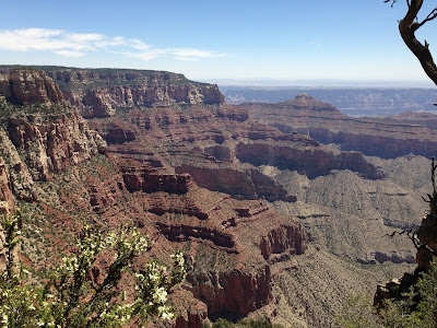
From the lodge's back porch we hiked a short trail down to Bright Angel Point for a lovely view of the canyon. I'll let the photos speak for themselves.

How about those hats?


Rick preferred the North Rim to the South Rim because there were no crowds, and it was much more green, while the South Rim was more desert-like. I preferred the South Rim because the vistas were more expansive, and I enjoyed the various museums and historical exhibits.

We spent three nights at the canyon. On our second day we took a long drive out onto the east rim, which had, perhaps, the best vistas in the park. Here are a few shots from that section of the park:
This is known as "Angel's window." If you enlarge the picture you can see the Colorado River at the bottom.


North Rim was nowhere nearly as dog-friendly as South Rim. The only trail SiSi was allowed on was one we didn't care about. So on our last day, we took SiSi hiking on a trail toward a nice view of the east rim. Since that hike was on forest service land, she was allowed to come and we kept her off-leash the entire time.

                                                      Are these Buffalo or Beefalo?
Good question! Bison are not native to this region. But they were brought to the area in 1906 in an effort to breed them with cattle and produce a heartier bison variety. The project wasn't economically successful and was abandoned several years later. The "Beefalo" have been running wild, and thriving, in the area ever since.

Friday, June 14, 2013

Bryce Canyon National Park

June 4 - June 11, 2013

It took me a while to warm up to this park. After really loving both Grand Canyon and Zion, Bryce just wasn't measuring up. It's a canyon, but nowhere as big or impressive as Grand Canyon. It's got pretty red rocks, but they're not as pretty or impressive as Zion. What makes it unique is something called "hoodoos" and I just wasn't feeling the hoodoos. But a couple of days into our stay we hiked down into the canyon and saw the hoodoos up close and personal. And that's when I started to warm up to Bryce.


SiSi  didn't care much about the hoodoos either


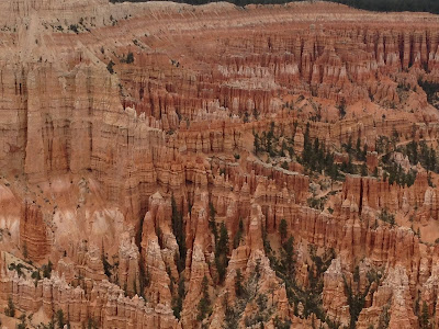
A hoodoo is an oddly-shaped rock formation created from millions of years of wind and water erosion. More interesting is the Paiute Indian legend that holds that these rocks were once evil people who were turned to stone by the Coyote spirit.  Here's a few snapshots of the park and some hoodoos.

The "amphitheater" taken from the canyon rim

This hoodoo is known as Thor's hammer
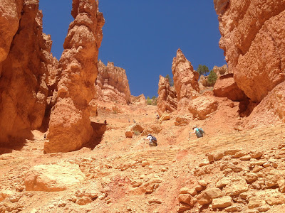
The fact that the canyon wasn't as overwhelmingly immense as Grand Canyon, and the fact that the rocks aren't as large as the rocks at Zion ended up making Bryce all the more accessible. All of the next group of photos were taken on our hike to the floor of the canyon, something I never would have dreamed of doing at Grand Canyon.


This shows the loooong hike we had back to the top. If you click on the picture you can enlarge it and see all the hikers on the switchbacks on their way to the top.


So far on this trip we have visited four national parks, not including monuments, historical parks, and presidential libraries. We have seen quite a bit of wildlife, including mule deer, pronghorn antelopes, elk, big horned sheep, and buffalo. But, by far, my favorite sighting was these three baby chipmunks. Betty, are they chipmunks or ground squirrels?

On June 6th we let ourselves get talked into attending a "western show and chuck wagon dinner" at a place called Ebenezer's Barn and Grill. It turned out to be one of the highlights of our trip! The food was quite good (my grilled salmon was amazing) and the entertainment was top notch. We were treated to a funny and quite professional performance by the "Bar-G Wranglers." They sung a wonderful collection of old western tunes and crowd favorites. While the audience was being seated the servers nonchalantly asked everyone where they were from. The crowd was quite international. Later, one of the singers asked folks from each different country represented to stand and cheer when he called out their country, and waved their flag. There was a big contingent from France, and they made a lot of noise when their flag was waved. The US was called last and the French all booed! We were stunned! Quick on his feet, the singer said "are you really booing the US on D-Day? Really?" That shut them up!

The Bar-G Wranglers
On another evening we attended the local county rodeo. It was fun! Unfortunately, this was the only picture we were able to take before the camera's battery died.


Saturday, June 8, 2013

Zion National Park

May 30 - June 4, 2013

Zion: (from the Hebrew) Place of refuge, Sanctuary, a place name often used as a synonym for Jerusalem.

We left Vegas just in the nick of time. We had had great weather while we were there, but the forecast called for 100 degree temperatures. Our intention was to spend a couple of days at a Nevada State Park called Valley of Fire about 60 miles down the road from Las Vegas. But after checking the forecast, we realized that it would break 100 there as well, so we decided to head to Zion National Park where highs were predicted in the upper 80's. We did take a quick detour through the Valley of Fire, though, and found it to be quite interesting with beautiful red rock formations.

The Liberty detours through Valley of Fire State Park

But as pretty as Valley of Fire was, it didn't hold a candle to Zion National Park. We arrived at Zion late on a Thursday afternoon to find the National Park Service campgrounds completely full. We settled for a commercial campground about a half mile from the park entrance. The spaces were tight and expensive, but we had full hook-ups, cable, and strong wifi. And best of all, we had an amazing view.

The Liberty's on the bottom right
You just couldn't get away from gorgeous views at Zion. The cute little gateway town of Springdale where we stayed had some nice restaurants and some funky little shops.

Here's the view from a café where we had dinner
 
Here are a few more typical Zion vistas:


These rocks are known as the 3 Patriarchs: Abraham, Isaac, and Jacob

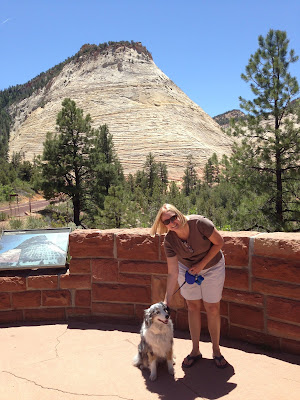
Sally and SiSi at Checkerboard Rock

The beautiful Virgin River runs through Zion Canyon, and is responsible for the unique nature of this park. There are significant altitude variations within Zion, specifically 3,700 to 8726 feet above sea level. So the presence of a water source, combined with an arid desert environment, and a large variation in altitude all create an incredibly unusual and diverse collection of plants and animals.

We took several different very pleasant hikes. They were all lovely, but our favorite was a trail called the Riverside Trail which followed the Virgin River into a place where the canyon became narrower and narrower until, eventually, all that was left was the river. When the Riverside Trail ends, many hikers continue hiking, in the river, on what's called the Narrows Trail, for several miles as the canyon becomes progressively narrower. We elected to stop at the end of the Riverside Trail, not having the proper equipment for the rest of the hike. Proper equipment would have included special waterproof shoes called 5-10 canyoneer hiking shoes, neoprene socks, and walking sticks.

One of the highlights of the Riverside Trail was the great views of what are called "hanging gardens." The extremely porous rocks allow water to seep though, and plants, flowers, and even trees actually grow on the sides of the rocks.
A "hanging garden"

This is where the Riverside Trail ended and the Narrows Trail began
The river was cold and clean and many hikers couldn't resist taking a dip
Another interesting hike took us to a spot known as "Weeping Rock." Here again, the porous rock allowed water from snow melt high above to seep through, creating hanging gardens and small waterfalls.


 Leaving Zion was a bit of an adventure. In order to reach our next stop, Bryce Canyon National Park, we had to drive the Liberty west on route 9, through the park. This involved passing through a mile long mountain tunnel which was built in the 30's by the Civilian Conservation Corps. Although the tunnel reached 13'2" in the center, the sides were much lower. Since the Liberty stands at 12'10", we needed a special permit and an escort to traverse the tunnel. Traffic had to be stopped in both directions (I'm sure they were cussing those damned RVers), and Rick had to steer the Liberty through the very center of the tunnel, straddling the center line. And if that wasn't bad enough, we had to unhook the Elantra, and I had to drive it through separately. Now, that may not seem so bad to everyone else, but anyone who knows me well knows that I've got a bit of a fear of heights, and this road required me to navigate multiple switchbacks up the mountain, some with no wall or guardrail between me and some certain death. I was terrified! Lucky for me, I preceded Rick into the tunnel. Since all traffic was stopped for Rick, I had no traffic behind me or in front of me, and I could crawl along at 10mph in my terrified state of mind with no one else behind me.

I neglected to take a picture of the tunnel, so I borrowed this one from the internet